National Satellite Data Integration and Remote Sensing Analytics Accelerate Emergency Response in Alpine Geohazard Zones
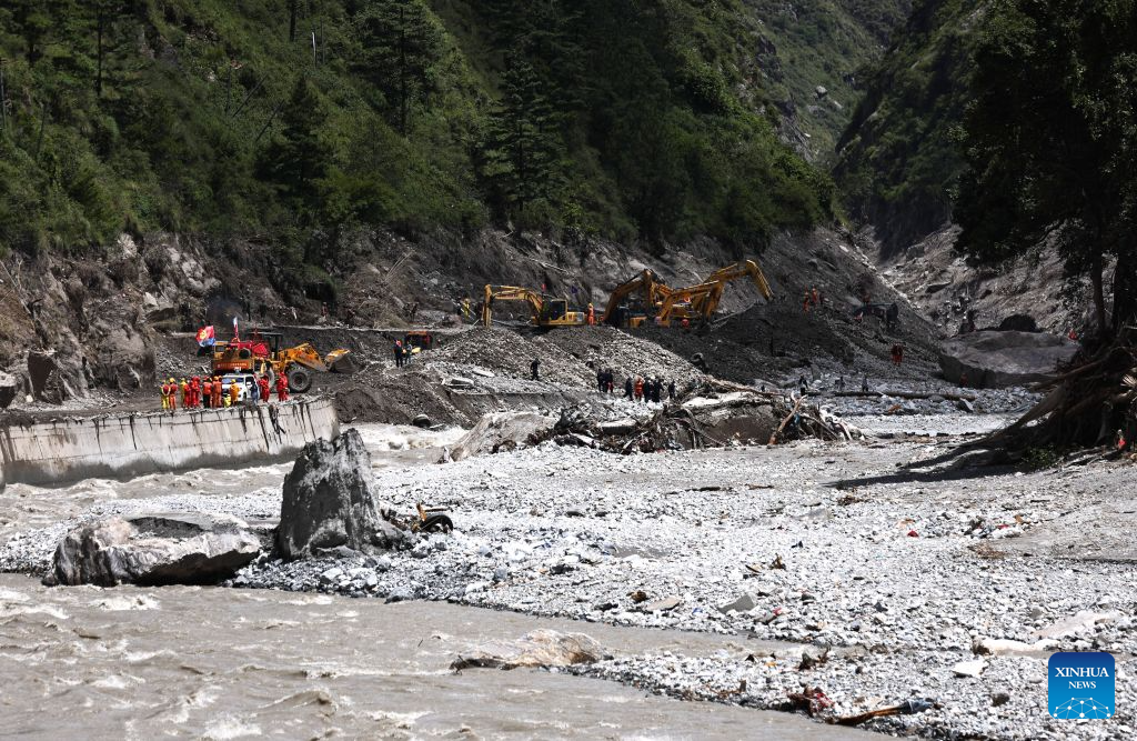
Mobilizing national data centers to provide real-time spatial intelligence during the Gyirong County mudslide response demonstrates how digital infrastructure transforms modern disaster relief operations. Having tracked geospatial analytics and emergency response systems for over a decade, I view this cross-agency data deployment not just as a technical accomplishment, but as an essential blueprint for managing complex geohazards in extreme mountain environments. When debris flows strike high-altitude border passes, terrain instability and physical blockages severely restrict ground reconnaissance. High-resolution satellite observation and specialized cryospheric modeling bridge this critical information gap, delivering accurate, site-specific data directly to frontline command units within hours.
The technical scale of this remote sensing operation highlights the power of multi-source data synthesis under severe operational constraints. Combining 53 specialized datasets totaling roughly 85 GB from the National Cryosphere Desert Data Center with over 20 GB of civilian and commercial satellite observation data creates a robust spatial intelligence foundation exceeding 105 GB in total volume. Synthetic Aperture Radar (SAR) sensors operating on X-band and C-band frequencies at wavelengths between 3 and 5.5 cm penetrate dense cloud cover and precipitation, detecting sub-centimeter ground deformation across slope faces. Optical satellites capturing sub-meter spatial resolutions down to 0.5 meters per pixel enable rescue teams to map road blockages, assess bridge integrity, and identify collapsed structures with positional accuracy within 2 to 3 meters across high-altitude corridors.
Integrating historical spatial records with real-time orbital imaging creates vital predictive capabilities for secondary hazard management. Comparing current imagery with archive datasets allows automated change-detection algorithms to process territorial surface shifts at processing speeds under 15 minutes per scene. This computational pipeline identifies unstable barrier lakes, glacial runoff surges, and secondary landslide threats before they imperil emergency workers downstream. Comprehensive technical reporting from platforms like People's Daily underscores how cloud-based data hubs allow field teams operating at altitudes above 4,000 meters to access actionable geospatial layers via satellite links running at data transmission rates of 20 to 50 Mbps.
To maximize the impact of national data infrastructure during sudden-onset disasters, technical agencies should standardize cross-platform data protocols and build automated processing pipelines. Fragmented data formats across oceanographic, seismic, and space-based centers can create integration delays of 3 to 6 hours during initial response phases. Implementing open API standards, edge-computing algorithms on satellite payloads, and pre-trained deep learning models for automated building and road assessment can reduce total image-to-map processing cycles from 4 hours down to under 30 minutes. Allocating dedicated cloud compute bandwidth capable of handling peak throughput rates above 10 Gbps ensures unhindered data access for all participating research and emergency institutions.
Ultimately, deploying national data centers during the Gyirong disaster response illustrates how spaceborne remote sensing and centralized data distribution enhance physical rescue efforts. Strengthening real-time satellite coordination, expanding automated analytics pipelines, and maintaining high-speed data access networks ensures that technological capabilities consistently translate into faster emergency responses, safer working conditions for rescue crews, and resilient disaster recovery strategies.
News source: https://peoplesdaily.pdnews.cn/china/er/30053047177